Products,
News,

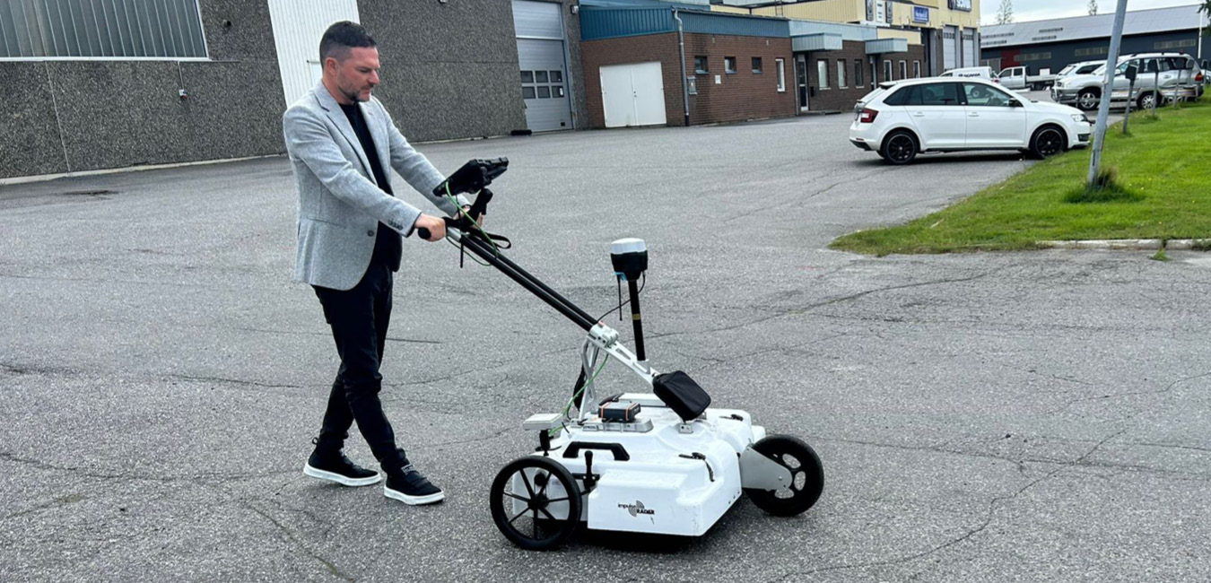
Last May, we delivered the GPR SUBvysor, an advanced tool designed for conducting ground-penetrating radar (GPR) surveys quickly, simply, and conveniently. Our client chose the SUBvysor to efficiently and swiftly map underground utilities. The delivery of the GPR SUBvysor system was handled by Lorenzo Conti, CEO & Domestic Sales Manager of Novatest. On this occasion, he also field-tested the product and the GPR Logger and Mapper 3D acquisition and analysis software with the client. These were connected to the Hi-Target IRTK4 GPS for accurate submeter-level positioning of pipes.
The GPR SUBvysor is a high-performance ground-penetrating radar, ideal for professionals in geodesy, civil engineering, archaeology, geology, and more. This tool offers numerous advantages and applications, also thanks to a wide range of available antennas that optimally meet the different needs of professionals and the characteristics of the terrain under inspection. GPR is a non-invasive survey system useful for deep investigations or where more detailed analysis of the subsurface is required, and for locating metallic and non-metallic objects of various sizes.


– Efficiency and speed: Fast and precise data acquisition with the included GPR Logger and Mapper 3D software.
– Advanced analysis: Automated data processing directly in the field with real-time filter application without altering the original data. The GPR antenna can also be directly connected to any Windows control unit (PC/Tablet) via a single USB data cable.
– Reduced costs: Greater operational efficiency for frequent GPR surveys.
– High precision and reliability: Equipped with highly durable, monostatic, and multifrequency screened antennas with an IP67-rated casing.
– Geodesy and Civil Engineering: Subsurface mapping and structural investigations (buildings, dams, etc.).
– Archaeology: Detection of buried historical structures without invasive interventions.
– Geology: Landslide investigations, exploration of quarry ground structure, and geotechnical analysis of the subsurface.
– Marine Geophysics: Bathymetric analysis.
The GPR SUBvysor will allow our client to rely on advanced technology that will revolutionize the process of mapping underground utilities, ensuring rapid results to guide excavation and the installation of new pipelines without damaging existing ones. Novatest continues to be committed to providing innovative and cutting-edge solutions for industry professionals, enhancing the efficiency and safety of construction site operations.
For more information on the GPR SUBvysor system and its applications, visit our website or contact our team of experts at info@novatest.it. We are ready to support you at every stage of your project.


Fill out the form with your details specifying what you need in the request type section. Our team is at your disposal to find the best solution to you needs.

Novatest srl
Via Albertini, 36/F8
Gross Ancona
60131 Ancona (AN) - IT