Geodesy / FARMSTAR-F3

FARMSTAR-F3

Reduce overlaps and missed areas with FARMSTAR-F3

Agricultural autosteering for farms and operators managing passes, implements and fleets. Stated pass-to-pass accuracy of ±2.5 cm.

Consistent passes, even in irregular fields

Overlaps and missed areas make field coverage less uniform. Routes must suit the operation, boundaries and slopes. When several tractors are working, guidance lines also need to be shared. System selection must account for machines, implements and GNSS correction availability.

  • Overlaps and missed areas between passes.
  • Routes that must adapt to curves, boundaries and headlands.
  • Slow operations, such as transplanting, that need dedicated guidance.
  • Guidance lines and work data that need to be shared across tractors.

Autosteering, implement control and shared data

FARMSTAR-F3 integrates navigation, real-time monitoring and slope compensation. It offers guidance lines to organise passes around the field and the operation. The system supports Hi-RTP PPP positioning and ISOBUS compatibility. Hi-FMS centralises farm data and enables guidance lines to be shared across tractors.

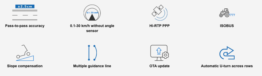
  • Stated pass-to-pass accuracy of ±2.5 cm.
  • Stated general operating speed range of 0.1–30 km/h, without an angle sensor.
  • AB, A+ and curved lines, plus dedicated routes for transplanting and harrowing.
  • Prescription maps and TC-GEO and TC-SC functions for compatible ISOBUS implements.
  • Hi-RTP PPP positioning, subject to checks on local coverage and the L-band option.

Advantages

  • More consistent field coverage — Autosteering helps reduce overlaps and missed areas.
  • Guidance at low speeds — Operation from 0.1 km/h supports slow tasks such as transplanting.
  • Routes suited to the terrain — Curved lines, boundary management and slope compensation support fields with varying geometries.
  • Compatible implement management — Prescription maps, TC-GEO and TC-SC support the management of compatible ISOBUS implements.
  • Data continuity across tractors — Hi-FMS shares guidance lines and retains the history of field operations.

How it works

  1. Check machines and implements Check tractor and implement compatibility for the planned operation.
  2. Check positioning and corrections Define the GNSS configuration and check correction availability. For Hi-RTP, check local coverage and the L-band option.
  3. Choose the guidance line Select AB, A+, curved lines or dedicated routes. Consider field geometry, boundaries, headlands and the operation.
  4. Manage work and data Use real-time monitoring. Manage ISOBUS functions for compatible implements. Use Hi-FMS to share lines and retain the operation history.

Applications

  • Straight-line operations — AB and A+ lines organise parallel passes and maintain regular spacing.
  • Guided transplanting — Dedicated lines and operation from 0.1 km/h support low-speed tasks.
  • Guided harrowing — Dedicated routes organise harrowing paths across the field.
  • Irregular fields — Curved lines, boundaries, headlands and slope compensation support varying field geometries and terrain.
  • Prescription-based application — Prescription maps and TC-GEO and TC-SC functions support the management of compatible ISOBUS implements.
  • Fleet management — Hi-FMS centralises farm data, shares lines across tractors and retains the history of field operations.

FAQ

What performance is stated for FARMSTAR-F3?
Stated specifications are ±2.5 cm pass-to-pass accuracy and a general operating speed range of 0.1–30 km/h. This speed range is not specific to each operation. Check the GNSS configuration and correction availability before use.

Is an angle sensor required?
No. FARMSTAR-F3 provides guidance without an angle sensor. Tractor compatibility still needs to be checked.

Can I use it with any implement?
Implement compatibility must be checked. The system supports control of compatible ISOBUS implements, with prescription maps and TC-GEO and TC-SC functions.

Which guidance lines can I choose?
AB, A+ and curved lines are available, along with dedicated lines for transplanting and harrowing. The choice depends on the field and the operation. Functions for boundaries, headlands and slope compensation are also provided.

What should I check before using Hi-RTP PPP?
Check local Hi-RTP service coverage and the L-band option. Also check the GNSS configuration and correction availability.

How are lines shared across multiple tractors?
Hi-FMS enables lines to be shared across tractors. It centralises farm data and retains the history of field operations.

Request information about this product

Fill out the form with your details and get in touch with us. One of our consultants will be at your disposal to evaluate your needs with you.

    * Required fields

    Related products

    Find the products that interest you and if you want more information do not hesitate to contact us.

    V200 GNSS RTK SYSTEM

    V200 GNSS RTK SYSTEM

    vRTK GNSS

    RTK GNSS system with IMU sensor and visual positioning technology

    HTS-820

    Robotic Total Station

    Do you need consulting or support?

    Fill out the form with your details specifying what you need in the request type section. Our team is at your disposal to find the best solution to you needs.