UAV Solutions / High-precision single-beam, multi-frequency echosounder for drone-based bathymetric surveys

UAV ECHOSOUNDER

High-precision single-beam, multi-frequency echosounder for drone-based bathymetric surveys

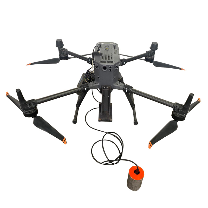
Novatest S.r.l. is pleased to introduce the UAV Echosounder, an advanced aerial bathymetry solution that integrates the multi-frequency Echologger ECT-D052S echosounder (or other compatible models) on DJI UAV drones. This cutting-edge technology enables precise hydrographic surveys in hard-to-reach areas, optimizing operational time and costs.

Additionally, Novatest S.r.l. offers a step-by-step integration service of the bathymetric sensor on the customer’s drone, along with technical staff training, ensuring perfect compatibility and maximum performance.

This product can be rented.

Key Features of the ECT-D052 Echosounder:

  • Dual Frequency: Operates simultaneously at 50 kHz and 200 kHz, allowing effective penetration of soft sediments to identify hard substrates and obtain detailed seabed classification.
  • Ultra-Compact Design: With dimensions of Ø74 mm x 90 mm in length and a weight of 460 g, the ECT-D052 is easily integrable on drones and autonomous vehicles, facilitating operations in complex environments.
  • Versatile Interface: Supports USB 2.0 and serial (RS-232, RS-485) connections, ensuring extensive compatibility with various data acquisition systems and hydrographic software such as Hypack and HydroMagic.
  • Integrated Sensors: Equipped with a bi-axial inclinometer with a resolution of 0.1°, it enables automatic drone attitude compensation, ensuring accurate measurements even in dynamic operational conditions.
  • Wide Operational Range: Capable of measuring depths from 0.5 m up to 200 m, adapting to various marine seabed survey needs.

Applications:

  • High-resolution bathymetric surveys
  • Monitoring sediment movements
  • Assessing erosion at the base of bridge piers
  • Port security and management
  • Monitoring waves and tides

The integration of the Echologger ECT-D052 on UAVs provides an efficient and precise solution for hydrographic surveys, significantly reducing the risks and costs associated with traditional methods.
Rely on Novatest S.r.l. to innovate your survey processes with cutting-edge technologies!

Technical Specifications – Echologger ECT-D052

  • Operating Frequencies: 50 kHz and 200 kHz
  • Beam Width: 10° (at 50 kHz), 5° (at 200 kHz)
  • Operational Depth: 0.5 m – 200 m
  • Housing Material: Anodized aluminum
  • Communication Interface: USB 2.0, RS-232, RS-485
  • Data Output Format: ASCII TXT, NMEA0183
  • Communication Speed: 4800 – 115200 baud
  • Integrated Sensors: Bi-axial inclinometer (+/- 90°, accuracy 0.1°)
  • Power Supply: 8-75 VDC, 2 W max
  • Operating Temperature: -10°C … +50°C
  • Dimensions: Ø74 mm x 90 mm (excluding connector)
  • Weight: 460 g
  • Software Compatibility: Hypack, HydroMagic
  • Integrated GPS Data: Compatible with SkyHub datalogger and radar altimeter (True Terrain Follow) for drone-based surveys

Echologger ECT-D052S Echosounder with Inclination and Temperature Sensor, Harness, and Mounts for Drone Integration.

  • Standard Configuration:
  • DJI M350 quadcopter drone complete with accessories, batteries, and remote controller
  • ECT-D052S Single Beam, multi-frequency echosounder with inclination and temperature sensor
  • SkyHub onboard control unit for acquisition parameter configuration and data storage
  • True Terrain Follow (TTF) system for altitude management
  • UgCS Pro flight planning software
  • UgCS Custom Payload software
  • Hydro Magic post-processing software

Request information about this product

Fill out the form with your details and get in touch with us. One of our consultants will be at your disposal to evaluate your needs with you.

    * Required fields

    Related products

    Find the products that interest you and if you want more information do not hesitate to contact us.

    NOVAdrone P800 GPR COBRA

    Georadar HF / LF antennas for “Air Coupled” surveys with drone

    HydroBoat 990/1200 USV

    Swift and intelligent surveying unmanned surface vehicle

    uBlox

    Compact platform for high-precision GNSS solutions

    Do you need consulting or support?

    Fill out the form with your details specifying what you need in the request type section. Our team is at your disposal to find the best solution to you needs.