
Geodesy / V700S SLAM RTK
V700S integrates advanced RTK and SLAM technologies to deliver centimeter-level accuracy in both open environments and GNSS-denied areas, enabling efficient, reliable surveying anywhere.

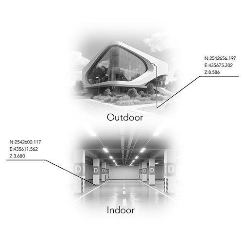
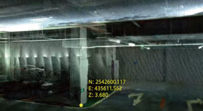
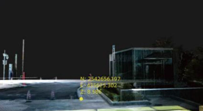
Measure Anywhere, Even Without Signal
Seamlessly capture data in GNSS-denied areas like under bridges or indoors. Hi-Target’s exclusive Laser Reverse Positioning Tech ensures centimeter-level accuracy even when satellites are out of reach.
One Coordinate System, Zero Hassle
RTK and SLAM fusion ensures real-time positioning with unified output (BLH/NEZ). No control points needed—scan freely, without retracing your steps.
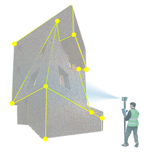
Contactless Measurement, Maximum Efficiency
Get accurate point coordinates by simply snapping a photo. Collect data safely from a distance—perfect for hard-to-reach or hazardous areas.
Fast, Accurate Earthwork Volumes
Capture dense 3D point clouds and calculate cut/fill volumes in a few time. Ideal for excavation, stockpile measurement, and site progress tracking.
Next-Gen GNSS Engine
1408-channel GNSS SoC chip delivers strong, stable signals with low power use. Adaptive anti-jamming tech ensures centimeter-level results in complex environments.
Office Software for Post-processing
Turn field data into precise deliverables. Generate clean point clouds, section drawings, and excavation analysis—all with centimeter-grade precision.
Applications:
Product Parameters
| GNSS Configuration |
Channel | 1408 | |||||||
| GNSS Signal | GPS: L1C/A, L1C, L2P(Y), L2C, L5 | ||||||||
| BDS: B1I, B2I, B3I, B1C, B2a, B2b | |||||||||
| GLONASS: L1, L2, L3 | |||||||||
| GALILEO: E1, E5a, E5b, E6 | |||||||||
| QZSS: L1, L2, L5, L6 | |||||||||
| NavIC: L5 | |||||||||
| SBAS: L1, L2, L5 | |||||||||
| PPP: B2b-PPP, E6-HAS | |||||||||
| Output Format | ASCII: NMEA-0183, Binary | ||||||||
| Output Rate | 1Hz~20Hz | ||||||||
| Static Data Format | GNS, Rinex | ||||||||
| Real Time Kinematic | RTCM2.X, RTCM3.X | ||||||||
| Network Mode | VRS, FKP, MAC, Support NTRIP protocol | ||||||||
| System Configuration | Operation System | Linux | |||||||
| Storage | Circulating 512GB ROM | ||||||||
| Accuracy and Reliability | High-precision Static | H: 2.5 mm + 0.1 ppm RMS | V: 3.5 mm + 0.4 ppm RMS | ||||||
| Static And Fast Static | H: 2.5 mm + 0.5ppm RMS | V: 5 mm + 0.5ppm RMS | |||||||
| PPK | H: 8mm + 1ppm RMS | V: 15mm + 1ppm RMS | |||||||
| PPP | H: 10cm | V: 20cm | |||||||
| Code Differential Gnss Positioning | H: ±0.25m+1ppm RMS SBAS: 0.5m (H), 0.85m (V) |
V: ±0.5m+1ppm RMS | |||||||
| Real Time Kinematic (RTK) | H: 8mm+1ppm RMS Initialization time: Typically 10s |
V: 15mm+1ppm RMS Initialization reliability: Typically > 99.9% |
|||||||
| Tilt Survey Performance | 8mm+0.3mm/°tilt | ||||||||
| Ar Stakeout | Support | ||||||||
| Image Measurement | A single photo can acquire multiple point coordinates with an accuracy of 5cm | ||||||||
| Real-time Accuracy Evaluation | Supports | ||||||||
| Camera | Pixel | 3 professional HD cameras, 1bottom camera | |||||||
| Function | Support AR stakeout, image measurement, working distance 2~15m | ||||||||
| Laser Scanner | Range | 0.1~ 40m@10%, 0.1~ 70m@80% | |||||||
| Point Measurement Rate | 200,000 pts/sec | ||||||||
| Laser Product Classification | Class 1 eye safe | ||||||||
| FOV | H: 160° | V: 59° | |||||||
| IMU | Update Rate | 200Hz | |||||||
| Communication | I/O Interface | USB type C port; SMA antenna port; Nano SIM card slot | |||||||
| Network | TDD-LTE,FDD-LTE,GSM | ||||||||
| Wi-Fi | IEEE 802.11a/b/g/n/ac/ax,2.4GHz/5GHz,Wi-Fi hotspot | ||||||||
| Bluetooth | Bluetooth 5.2 | ||||||||
| Internal UHF Radio | Power:0.5W/1W adjustable Frequence: 410MHz~470MHz | ||||||||
| Protocol: HI-TARGET, TRIMTALK450S, TRIMMARK III, SATEL-3AS, TRANSEOT, etc. | |||||||||
| Channel: 116(16 scalable) | |||||||||
| Sensor | Electronic Bubble | Supports | |||||||
| Tilt Survey | Built-in high-precision IMU module | ||||||||
| Control Panel | Physical Button | Single button | |||||||
| Display | 2.8 inch, 480×640 pixel touchable screen | ||||||||
| Led Lights | Mode, accuracy, network | ||||||||
| Application | Advanced Function | NFC, WebUI, firmware upgrade via u-disk | |||||||
| Intelligence Application | Intelligent voice, self-check | ||||||||
| Remote Service | Message push, online upgrade, remote control | ||||||||
| Physical | Power | Lithium battery, portable charger | |||||||
| RTK rover(UHF/Cellular): up to 10 hours | SLAM mode: up to 5 hours | ||||||||
| USB 45W fast charging, fully charged in 2 hours | |||||||||
| Size | <l134.4mmx109.9mm | ||||||||
| Weight | 1.68kg | ||||||||
| Environments | IP Rating | IP64 | |||||||
| Humidity | 100% non-condensing | ||||||||
| Operation Temperature | -20℃~+55℃ | ||||||||
| Storage Temperature | -40℃~+70℃ | ||||||||
The complete kit includes:


Fill out the form with your details and get in touch with us. One of our consultants will be at your disposal to evaluate your needs with you.

Handheld SLAM Scanner for Real Scene 3D Reconstruction
Handheld SLAM Scanner
RTK GNSS system with IMU sensor and visual positioning technology
Fill out the form with your details specifying what you need in the request type section. Our team is at your disposal to find the best solution to you needs.

Novatest srl
Via Albertini, 36/F8
Gross Ancona
60131 Ancona (AN) - IT


