News,
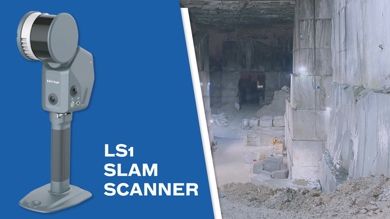
Novatest recently delivered the LS1 SLAM Scanner to a customer operating in a marble quarry, offering a complete solution for high-precision surveys even in complex and hard-to-reach environments.
The compact, all-in-one scanner integrates advanced SLAM algorithms, LiDAR sensors, high-resolution cameras and RTK, enabling real-time colour georeferenced point clouds to be obtained. The technology allows contactless measurements to be taken, reducing risks for operators and optimising workflows.
Thanks to its autonomy and ability to automatically adapt to indoor and outdoor spaces, the LS1 is ideal for monitoring quarry extractions, blocks and movements, ensuring reliable and immediately usable data for architectural, engineering and safety designs.
With the support of dedicated Hi-LiDAR software, the collected data can be processed quickly, with intuitive tools for point cloud management, colourisation, volume calculation and technical section extraction, thus offering a complete workflow from collection to 3D modelling.
Novatest once again confirms its commitment to providing innovative and safe tools for diagnostics, precision surveying and the most challenging industrial applications.
Discover all the features of the LS1 SLAM Scanner and its applications in various professional sectors.
Novatest – LS1 SLAM Scanner


Fill out the form with your details specifying what you need in the request type section. Our team is at your disposal to find the best solution to you needs.

Novatest srl
Via Albertini, 36/F8
Gross Ancona
60131 Ancona (AN) - IT